by R.I. Pienaar | Dec 24, 2006 | Front Page
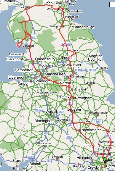
We are now back from holiday after driving 1065 miles (1713 kilo meter).
We decided to cut 2 days out of our plans for the trip due to the persistent fog. First few days we had great weather, when the fog first set in it was fine as well as we were at Fountains Abbey where it added great atmosphere to everything, then we visited Emma’s sister so no big deal. Last 2 days where primarily days for seeing the beauty of the lake and peak districts and we had zero visibility, so we decided to cut the Dean Forest days out out of the trip.
I used my trusty old Magellan GPS 315 to record the trip, one day I didn’t use it as we were mostly just driving around New Castle, also didn’t record short trips to restaurants and the like, therefore it’s total distance is a bit out, only 947 miles on the track.
Average Speed: 63 km/hour
Max Elevation: 450 meter / 1473 feet
The car behaved perfectly, no hitches or complaints at all and overall I had a great time on the holiday.
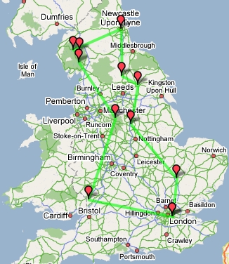
I made the track using my GPS track management application that I’ve blogged about before, I’ll turn it into a interactive google map with links to places, pictures etc and link it here later.
by R.I. Pienaar | Dec 15, 2006 | Front Page
Last night while packing for my holiday it struck me just how bad things are today with all the gadgets and stuff we carry around. I guess the list of things I packed says it all:
| USB Cable for WM5 phone and photovault |
Laptop + Charger |
| Lensbaby |
DSLR Cleaning kit |
| USB card reader |
GPS data cable |
| Backup mobile phone on a different network |
4 x AA batteries and charger |
| USB Speakers for watching divx |
6 x Ilford HP5+ films |
| Spot Meter |
2 x Ilford FP4+ films |
| Nikon FM3a |
Nikon FE |
| 12 to 220 volt adapter for car |
D70 + Battery + Charger |
| Road Atlas |
TomTom Navigator with latest speed cams loaded |
| WM5 Phone + Charger |
Tourist books, reading books |
| D80 + Grip + 4 x AA Adapters + 18-200VR |
Flash Light |
| 5 x Memory Cards |
Tri-Pod |
| Notebook + Pen |
Photovault |
That’s about it, all of this before even starting on clothing and other such things. Insane.
Anyway, so a bit about the holiday, we’re just doing a bit of a road trip to test out my new car, I only have 6 days leave this year after changing jobs and loosing 16 days worth in the process so this is all we really have time for 🙁
The major stops are basically Cambridge (today), Bolsover for a castle there, York, New Castle, Lake District, Peak District and Royal forest of Dean, we’ll be back around christmas day.
by R.I. Pienaar | Dec 6, 2006 | Usefull Things
I’ve previously written that I am trying out lighttpd for serving up my static files, I’ve now been running lighttpd and apache in parallel for a while and must say the results are very good in favour of lighttpd.
First a graphic to show the change:
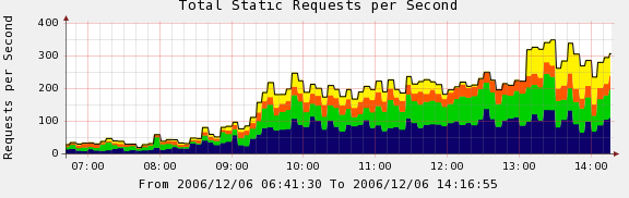
This is a capture out of cacti showing the requests per second for some servers. Look at the yellow line, till about 12 it was running Apache 1.x, then I took that server out, around 12:30 I put in a lighttpd server on the same box and enabled stats from it around 13:00. This is on the same hardware, same files etc same IP address and you can clearly see in terms of requests per second lighttpd totally flies compared to Apache on the same box.
The Apache is a stock Debian Apache 1.3.33, I could probably have sped it up by some tuning, but installing lighttpd is much less work and much less painstaking monitoring, tuning, monitoring, tuning.
by R.I. Pienaar | Nov 29, 2006 | Code
GMapEZ has supported drawing lines using the Google Maps API for a while now, but I’ve always put off implimenting this since I thought it would be quite a bit of work and involve lots of changes in my XML format. I finally decided to impliment it today and I found a very easy way to assign points to lines.
First an example map so you can see what you can achieve:
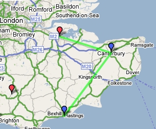
The line thickness, color and opacity is configurable on a per-line basis and you can assign any point in your existing data file to a line on the map, to achieve this I extended the XML data using a <linemember> element, here is an example point:
<point>
<lat>51.393522</lat>
<long>0.527054</long>
<type>visit</type>
<title>Chatham Historic Dockyard</title>
<country>England</country>
<href>http://www.chdt.org.uk/</href>
<linktext>Home Page</linktext>
<linemember>1</linemember>
</point>
The points on the line get connected in order that they appear in your data file.
To configure the line created above you can add a [line1] section to your configuration file, simply match up the linemember numbers with the lineX section in your config, a sample:
[line1]
color = #00ff00
width = 2
opacity = 0.6
This will draw the line in the image above, I think it’s very simple and it should be 100% backward compatible with your exiting data should you choose not to use this feature.
As always you can get the code at http://www.devco.net/code/gmapsphp-current.tgz the documentation at http://www.devco.net/pubwiki/GMapsPHP has also been updated to reflect these changes.
by R.I. Pienaar | Nov 15, 2006 | Usefull Things
I’ve been struggling through some web development, it really is the worst kind of development possible. I’m developing an application to track my films, chemicals, cameras and development methods, so it needs a lot of stupid little buttons.

Today I cam across Buttonator.com, the site basically has a number of templates for the kind of button people use these days and let you put your own text in any color on them, simple stuff but a real time saver. If you open an account you can upload your own template buttons and have it do the text for you.
