As mentioned in my previous 2 posts I’ve been working on rebuilding my travel tracker app. It’s now reached something I am happy to call version 1.0.0 so this post introduces it.
I’ve been tracking major travels, day trips etc since 1999 and plotting it on maps using various tools like the defunct Xerox Parc Map Viewer, XPlanet and eventually wrote a PHP based app to draw them on Google Maps. During the years I’ve also looked at various services to use instead so I don’t have to keep doing this myself but they all die, change business focus or hold data ransom so I am still fairly happy doing this myself.
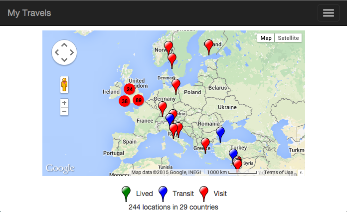
The latest iteration of this can be seen at travels.devco.net. It’s a Ruby app that you can host on the free tier at Heroku quite easily. Features wise version 1.0.0 has:
- Responsive design that works on mobile and PC
- A menu of pre-defined views so you can draw attention to a certain area of the map
- Points can be catagorized by type of visit like places you've lived, visited or transited through. Each with their own icon.
- Points can have urls, text, images and dates associated with them
- Point clustering that combines many points into one when zoomed out with extensive configuration options
- Several sets of colored icons for point types and clusters. Ability to add your own.
- A web based tool to help you visually construct the YAML snippets needed using search
- Optional authentication around the geocoder
- Google Analytics support
- Export to KML for viewing in tools like Google Earth
- Full control over the Google Map like enabling or disabling the street view options
It’s important to note the intended use isn’t something like a private Foursquare or Facebook checkin service, it’s not about tracking every coffee shop. Instead it’s for tracking major city or attraction level places you’ve been to. I’m contemplating adding a mobile app to make it easier to log visits while you’re out and about but it won’t become a checkin type service.
I specifically do not use a database or anything like that, it’s just YAML files that you can check into GitHub, easily backup and hopefully never loose. Data longevity is the most important aspect for me so the input format is simple and easy to convert to others like JSON or KML. This also means I do not currently let the app write into any data files where it’s hosted. I do not want to have to figure out the mechanics of not loosing some YAML file sat nowhere else but a webserver. Though I am planning to enable writing to a incoming YAML file as mentioned above.
Getting going with your own is really easy. Open up a free Heroku account and set up a free app with one dynamo. Clone the demo site into your own GitHub and push to Heroku. That’s it, you should have your own up and running with place holder content ready to start receiving your own points which you can make using the included geocoder. You can also host it on any Ruby based app server like Passenger without any modification from the Heroku one.
The code is on GitHub ripienaar/travlrmap under Apache 2. Docs for using it and configuration references are on it’s dedicated gh-pages page.
